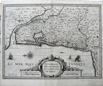
(France) Bourdelois…Amsterdam: Judocus Hondius, c. 1620
$500.00
“Bourdelois Pays De Medoc et la Prevoste de Born”
This wonderfully strong crisp impression of a beautifully engraved early 17th century map shows the Medoc region of France. The Medoc is the famous wine growing region of southwestern part of the country located in department Gironde. The area is renowned for its production of excellent Bordeaux wines including Chateau LaTour, Chateau Rothschild, and Chateau Margaux.
The compass rose indicates that the map is oriented with north (and the Garonne River) to the left of the sheet. Elaborate Baroque decoration encircles the cartouche and sailing ships and a sea creature populate “la mer Aquatanique.”
17 ¼ x 20 ¾ inches, sheet.
Copper plate engraving.
Excellent condition.
1 in stock