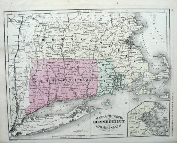
McNally, Francis. Massachusetts, Connecticut and Rhode Island. New York, 1866
$75.00
“Massachusetts, Connecticut and Rhode Island”
A pretty hand colored antique map from
McNally’s System of Geography
.
The map includes depictions of the New York towns on the east and west of the Hudson River starting with Brooklyn on the south and as far north as Schenectady. Fisher’s Island is clearly depicted off of Connecticut, Little Compton, NMewport, etc in Rhode Island, and Cape Cod, Martha’s Vineyard and Nantucket Island in Massacjusetts. There is an inset of Boston and Vicinity.
9 1/2 x 11 1/2 inches.
Hand colored lithograph.
1 in stock
![S. Augustus Mitchell (Boston) New General Atlas. Philadelphia [1860]-1864](http://fineantiqueprints.com/wp-content/uploads/2025/08/MitchellBoston-300x300.jpg)
