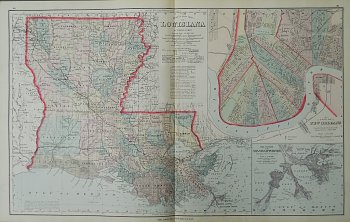
New Map of Louisiana, published Philadelphia 1876
$395.00
This detailed state map of Louisiana was published in 1876 in
Gray’s Atlas of the United States with General Maps of the World. Accompanied by Descriptions Geographical Historical Scientific and Statistical.
It shows a state neatly divided into counties with criss-crossing railroad lines. With a wonderful full detailed inset of New Orleans and the Mississippi River, this map is a great reference to the state of Louisiana as it appeared at the Centennial year of the United States. Hand colored lithograph measuring 17 ½ x 28 inches sheet size. Excellent condition.
1 in stock