
Johann Meyer. ...Ohio. 1846. $325.00
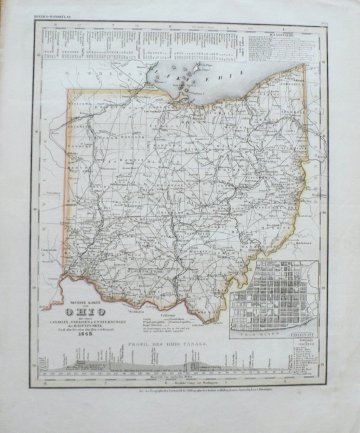
Included in Meyer’s Grosser Hand Atlas.
Hildburghhausen, Amsterdam, Paris and Philadelphia, 1846.
Maps included in Meyer’s atlas were very skillfully engraved so that roads, rivers, places names, and topographical features are clearly legible. This sheet depicts the state of Ohio including wonderfully detailed information in two insets: The map includes a large scale inset plan of Cincinnati and a profile of the Ohio Canals. Across the top is a scale of distances from major Ohio cities.
Engraving with hand coloring.
14 ¾ by 18 inches sheet.
Very good condition overall with minor damp staining in margins, beyond plate.
or click to inquire about this print.