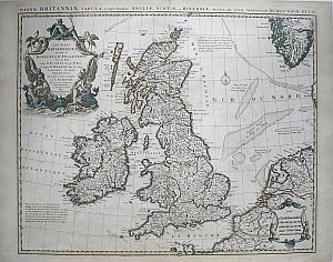
(British Isles) Delisle, Guillaume. Amsterdam: Covens & Mortier, 1708. $675.00

Guillaume Delisle.
“Les Isles Britanniques our sont le Royaumes D’Angleterre…”
A wonderfully decorative map of England, Wales, Scotland and Ireland that also shows northern portions of coastal France, part of the Netherlands and the southern tip of Norway. The title is surrounded by an elaborately and beautifully engraved depiction of mermen on horseback, fishing nets, strong marine roping, a porpoise, herons, etc. capped by a seated figure of the sea god Neptune wearing a crown and holding a scepter.
Guillaume Delisle is the most famous French cartographer of the early 18th century. As a member of the Academie Royale des Sciences and later, the Premier Geographe du Roi, he had access to the most up to date geographical information and he included it in his important maps. This map was included in his A New General Atlas.
In this map all is depicted in enormous yet easy to read detail including town names, divisions of shires and provinces, the location of grand estates and chateaux, shoals and underwater trenches.
20 x 25 ¼ inches, sheet.
Engraving with original hand colored outlining.
Excellent condition with light overall patina.
or click to inquire about this print.
