
(Caribbean, West Indies) Robert de Vaugondy. Paris, 1757. $950.00
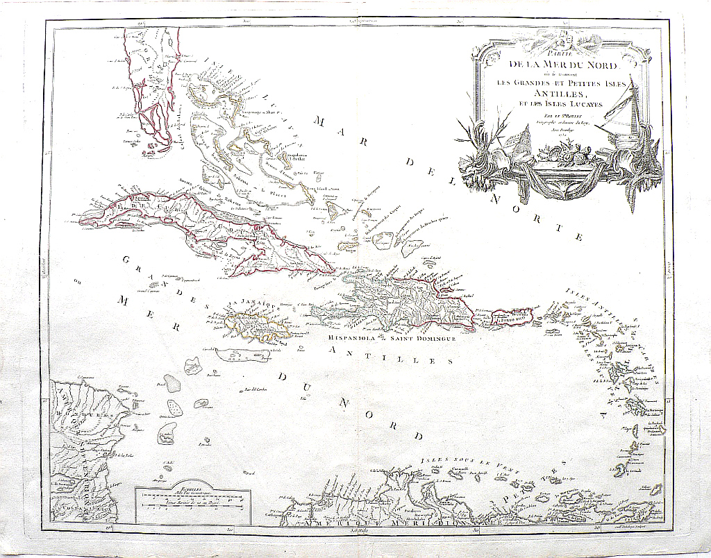
"Partie de La Mer du Nord, ou se trouvent Les Grandes et Petites Isles Antilles, et les Isles Lucayes."
Robert de Vaugondy (1688-1766) also known as Le Sieur or Monsieur Robert to distinguish his work from that of his son Didier Robert de Vaugondy, was the preeminent French mapmaker in the 18th century. This map was included in his Atlas Universel, published in Paris in 1757, and one of the most important atlases of its time. Their maps represented a great step forward in terms of the detail shown and accuracy of the depiction. They combined information gleaned from earlier sources with that of recently completed surveys and verified and corrected latitude and longitude measurements and added many new places names. In recognition of this atlas’s tremendous contribution to cartography, Robert de Vaugondy was appointed geographer to King Louis XV in 1760.
This map of the Caribbean extends from central Florida to Honduras and the southernmost past of South America. It is centered on the island containing Hispaniola and Saint Dominque (now the Dominican Republic) the two countries not yet having been divided and shows the Bahama Islands (or Lucayes), The Greater Antilles (Cuba, Hispaniola and Saint Dominque the two countries not yet having been divided) the Cayman Islands, Jamaica, and Puerto Rico, the Lesser Antilles or Caribbees including the Leeward islands of St. Thomas, St. John, St. Croix, the Virgin Islands, Tortola, Virgin Gorda, Anguilla, Saint Martin, Saint Barthelemy, Saba, Saint Eustatatius, Saint Kitts, Nevis, Barbuda, Antigua, Redonda, Montserrat, Guadeloupe, and Dominica and Windward Islands of Martinique, Saint Vincent, Saint Lucie, the Grenadines, and Grenada. The commodities exported from these islands made them important European possessions and the mapmaker has taken pains to note the ownership of each.
De Vaugony maps are noted for the beauty of the ornamental engraving surrounding their title areas. In this case, merchant vessels, fishing nets, a collection of sea shells and wind blowing cherubs.
20 5/8 x 26 ½ inches, sheet.
Engraving hand colored outlining.
Very nice condition with wide margins.
or click to inquire about this print.