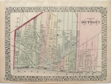
Mitchell. S. Augustus. (Plan of Detroit) Philadelphia, 1873. $150.00

Mitchell, S. Augustus Mitchell. (Plan of Detroit) Philadelphia, 1873.
Shows Michigan Central railroad lines and the Central Depot as well as Detroit and Milwaukee railroad and that railroad’s depot.
The current Midtown section of the city is at the center of the map. The depiction stretches from 24th Street (now Routes 9 and 75) on the west to Mt. Elliott Street and cemetery on the east, the Detroit River in the south and to the North End.
Hand colored lithograph.
Approximately 11 ½ x 15 inches, sheet.
Excellent condition.
or click to inquire about this print.
