(Hispaniola, Dominican Republic, Haiti) Bryan Edwards. The History Civil and Commercial of the British Colonies of the West Indies, 1800, London John Stockdale 1800. $695.00

(Hispaniola, Dominican Republic, Haiti) Bryan Edwards. The History Civil and Commercial of the British Colonies of the West Indies, 1800, London John Stockdale 1800.
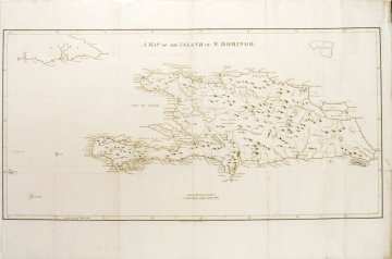
The Caribbean islands were a huge source of wealth for the colonial powers who annexed them in the 18th century. Great plantations of sugar cane and other tropical crops were built and worked by enslaved peoples. Bryan Edwards was a Jamaican planter and politician who published a number of texts on the history of the islands, communicating the white planter's view concerning these colonies and the value of slave trade. His arguments were persuasive and his publications well received. His accurate and well researched map of the island of Hispaniola was copied by a number of English cartographers resulting in one of the earliest British copyright cases.
This large map was folded into its text making these folds original and as issued. Edwards charted rivers, mountains, towns, and the demarcation line between French holdings (Haiti) and Spanish territory (Dominican Republic).
Copperplate engraving uncolored as issued.
18 x 36 inches sheet.
Excellent condition.
or click to inquire about this print.
