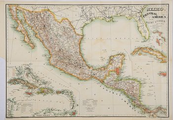
(Mexico, West Indies...) Philadelphia: J.M. Stoddard, 1884. $150.00
 “Mexico, Central America and the West Indies.”
This large, attractive map with beautiful coloring focuses on Mexico, Baja California and Central America extending as far south as the Panama Canal but it also depicts the coast of Florida, the American Gulf coast, Cuba, Andros. Nassau, Eleuthera, the Bahama Islands and Jamaica. An inset at lower left provides an even more detailed depiction of all of the Bahamas, Cuba, the Cayman Islands, “S. Domingo”, Porto Rico, the Leeward and Windward Islands, south to Tortuga and the coast of Venezuela.
The lithographer, F. Moras of Philadelphia produced a remarkably detail and readable map based upon the information provided by W. H. Holmes.
Hand colored lithograph.
20 ¼ x 28 inches, sheet.
Very good condition overall.
Trimmed to outside of neat line on lower left with small repaired tear.
Minor discoloration in Gulf of Mexico.
or click to inquire about this print.
