
(Netherlands) Visscher, Nicholas. Amsterdam: ca. 1680. $395.00
"Novissima Comitatus Zutphanie Totiuso Fluminis Isulae Descriptio"
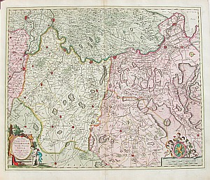
For one hundred years, beginning in the last quarter of the 16th century, Dutch mapmakers were in the forefront of cartography. Their maps contained the most up-to-date geographical information and were usually elaborately engraved with illustrations surrounding the title area, the scale of miles or elsewhere on the sheet. The Blaeu, Janson and Visscher families were the three most powerful dynasties of mapmakers during this period.
This beautiful and highly detailed map by Visscher is in excellent condition with the original vibrant coloring perfectly preserved. Since it was not until the eighteenth century that it became customary to show north to the top of the page, an engraved compass rose indicates the orientation of the map, a compass rose on the right side of the map reveals the orientation with north to the right of the page. Therefore, this map depicts the southeastern Netherlands from Nijmegen in the south, north to "Campen" at the mouth of the "Zuyder Zee" at the far top right and inland to the border of present day Germany. The enormous detail includes many towns with the sizes of the settlements indicated, and the location of castles, windmills and churches shown. The areas around the title and the scale of miles are decorated with putti and a coat of arms.
22 x 26 inches.
Hand colored copperplate engraving.
Excellent condition with original coloring and full margins.
or click to inquire about this print.