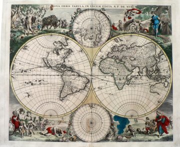
Frederick De Wit. (World) Amsterdam, ca. 1670. Sold

“Nova Orbis Tabula In Lucem Edita..”
This is one of the most attractive of all world maps. It was published in Holland in the late 1600’s during the period of the golden age of Dutch cartography. It is also cartographically important. The depiction of California is based upon the Briggs 1622 model of California as an island. Despite the appearance of information indicating that the land mass was probably a peninsula and then proof that that was the case, the erroneous concept was so intractable that some mapmakers continued to publish maps showing California as an island for well over one hundred years. This map also shows the “Straits of Anian” in the Pacific Northwest. They were a semi-mythical waterway extending between northeastern Asia and the North American Pacific west coast that would allow easily navigable passage through to the Hudson Bay thereby sparing sailors the dangerous trip around the tip of South America. Two insets show the north and south poles.
The highly decorative scenes filling the four corners of the map include images of the four seasons, the signs of the zodiac and the elements. Spring is represented by a joyous and fecund female figure with garlands in her hair, surrounded by cupids, early blooming flowers, a bull festooned with flowers and a ram. Summer is represented by figures engaged in the agricultural industries of summer and a cupid holding a lobster. Autumn consists of Bacchus and rabble rousing satyrs enjoying the fruits of the vine, some to excess. Wintry blasts of cold air descend upon the figures in the lower right.
This is the first state of the map before the addition of the outer border making this an early, ca. 1670 impression.
20 ¼ x 24 ¼ inches, sheet.
Hand colored engraving.
Professionally removed from the backing boards and reinforced along the centerfold. There is some evidence of glue residue along the centerfold at bottom and a small repaired tear in the center bottom margin. A very good impression overall.
Framed to museum specifications.
